
Results 1 to 10 of 17
 27Likes
 LinkBack URL
 About LinkBacks
-
01-09-2025, 12:45 PM #1We are there! Let's go fishing!!


- Join Date
- Oct 2011
- Location
- Born, bred and someday dead in Midtown Mobile, AL
- Posts
- 10,275
- Thanks
- 8,079
- Thanked 13,811 Times in 4,061 Posts
- Blog Entries
- 6
ARCOS on the Gulf State Park Pier
The good folks at Alabama's Real-Time Coastal Observing System (ARCOS) at the Dauphin Island Sealab have done an excellent job with a very limited budget creating a network of weather/hydro automated stations around coastal Alabama.
I have participated in their feedback program for several years, and when they asked where the next station should be located my suggestion was the Gulf State Park Pier.
The sensors are in still being calibrated but most of the meteorological (weather) data is now available @ https://www.disl.edu/arcos/gulf-state-park-pier/
Hopefully the hydrographic instruments will soon be online too...
-
-
01-10-2025, 09:12 AM #2Senior Member


- Join Date
- Oct 2011
- Location
- Upstream in WV
- Posts
- 458
- Thanks
- 1,400
- Thanked 530 Times in 159 Posts
Educate me a little bit if you will. What are good turbidity numbers? If you can check those stats and determine what the water looks like before you go, that would be VERY helpful!
God bless!
-
01-10-2025, 06:08 PM #3Senior Member
- Join Date
- Jul 2013
- Posts
- 360
- Thanks
- 173
- Thanked 372 Times in 128 Posts
Great question Dave While weve got #rs attention here Id like to know how close we are to Navarres water temp Which is where Surfline pulls there info I usually subtract 2 degrees due to the nipple vein ! Stoked about the news-that will give John a break at the pier 🤙
-
01-11-2025, 01:34 PM #4Senior Member
- Join Date
- Apr 2013
- Location
- Foley, AL
- Posts
- 1,607
- Thanks
- 1,243
- Thanked 1,829 Times in 518 Posts
A good way for us to all "calibrate" the turbidity numbers will be for people to report their general impression of visibility pretty often (including time of day) at the station.
Which brings up a point, where on the pier is the station/sensor?People are shocked to see sharks in the water around here.
If you see natural water taste it. If it's salty it has sharks in it. If it's fresh it has alligators in it. If it's brackish it has both.
-
The Following User Says Thank You to frednic For This Useful Post:
-
01-11-2025, 11:59 PM #5We are there! Let's go fishing!!
- Join Date
- Oct 2011
- Location
- Born, bred and someday dead in Midtown Mobile, AL
- Posts
- 10,275
- Thanks
- 8,079
- Thanked 13,811 Times in 4,061 Posts
- Blog Entries
- 6
The sensors are located on the middle octagon.
Cajun took this picture of the work Friday ...
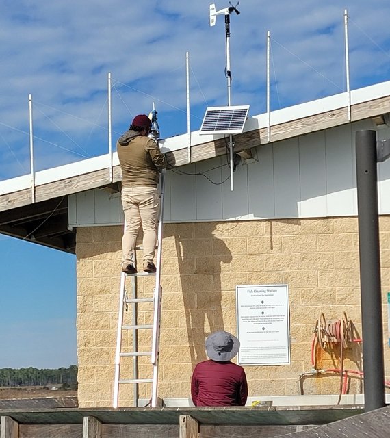
Last edited by Pier#r; 01-12-2025 at 12:01 AM.
-
The Following User Says Thank You to Pier#r For This Useful Post:
-
01-12-2025, 12:15 AM #6We are there! Let's go fishing!!
- Join Date
- Oct 2011
- Location
- Born, bred and someday dead in Midtown Mobile, AL
- Posts
- 10,275
- Thanks
- 8,079
- Thanked 13,811 Times in 4,061 Posts
- Blog Entries
- 6
Exactly Dave.
Turbidity is a measure of how clear water is, or how much light is scattered by particles in the water. Turbid water appears cloudy or muddy (dingy).
The particles that scatter light may be inorganic (silt stirred up by wind & waves), or organic (biological bacteria or algae suspended in the water).
Like frednic said it will take a little referencing to interpret how the numbers compare to what you are seeing from the pier, but it is a remarkable tool I have been using at other locations for years.
So glad to have it on the pier now.
-
-
01-12-2025, 07:26 AM #7Senior Member
- Join Date
- Feb 2014
- Location
- Foley, AL
- Posts
- 2,438
- Thanks
- 2,783
- Thanked 8,463 Times in 1,235 Posts
Thanks, David. Great information!
-
01-12-2025, 11:23 AM #8Senior Member
- Join Date
- Apr 2013
- Location
- Foley, AL
- Posts
- 1,607
- Thanks
- 1,243
- Thanked 1,829 Times in 518 Posts
FWIW, I found this site.
https://waterontheweb.org/under/wate...turbidity.html
If you scroll down to "What in the world are Nephelometric Turbidity Units (NTU’s)?" you will see some picture examples.
I used to fill out reports on this stuff about 45 years ago, but I can't remember it all. IIRC we had a limit of 18 NTU's for rainfall events on reclaimed land and that water would have been quite fishable.
Edit: If you are curious about "FORMAZIN" - https://en.wikipedia.org/wiki/Formazine
It's just something they use to standardize/calibrate meters.eym_sirius and OldSpool like this.People are shocked to see sharks in the water around here.
If you see natural water taste it. If it's salty it has sharks in it. If it's fresh it has alligators in it. If it's brackish it has both.
-
01-12-2025, 11:43 AM #9Senior Member
- Join Date
- Apr 2013
- Location
- Foley, AL
- Posts
- 1,607
- Thanks
- 1,243
- Thanked 1,829 Times in 518 Posts
@ Pier#r, is the "Depth" they report the SECCHI depth that is shown if you scroll down a little more on that "waterontheweb" site? If it's that, or something similar, then that's probably a number we will want to pay attention to.
jjfish likes this.People are shocked to see sharks in the water around here.
If you see natural water taste it. If it's salty it has sharks in it. If it's fresh it has alligators in it. If it's brackish it has both.
-
01-12-2025, 12:28 PM #10Senior Member
- Join Date
- Jun 2012
- Location
- Foley, AL.
- Posts
- 219
- Thanks
- 83
- Thanked 89 Times in 36 Posts
I wonder if there’s an app that will show these conditions.
Remember Duane Allman


 Reply With Quote


I tried to edit my original post and it just disappeared when I saved. IDK.
Winter Fish - How to catch them!