
Results 1 to 9 of 9
 16Likes

Thread: Cause of dingy water
 LinkBack URL
 About LinkBacks
-
05-29-2025, 07:13 PM #1Senior Member

- Join Date
- Oct 2011
- Posts
- 198
- Thanks
- 57
- Thanked 282 Times in 87 Posts
Cause of dingy water
As most are aware, the water at the pier has been pretty dingy lately. West winds and heavy rains locally or even hundreds of miles away can cause this. Recently, the dirty water has been at least 20 miles offshore, which is quite uncommon, although not unheard of. I have been hearing rumors that the mud dumping in Mobile Bay is contributing to this. Does anyone have evidence that supports this? Or do you believe that has little to do with the dingy water we are currently experiencing?
-
05-29-2025, 11:38 PM #2We are there! Let's go fishing!!

- Join Date
- Oct 2011
- Location
- Born, bred and someday dead in Midtown Mobile, AL
- Posts
- 10,235
- Thanks
- 8,025
- Thanked 13,654 Times in 4,027 Posts
- Blog Entries
- 6
Yes, I have evidence as to the cause of the muddy water plume the pier has been experiencing lately.
It is due to flooding of the Mobile River from heavy rainwater runoff upstate.
That situation improved slightly this week, but more flood water is coming down river that will last into the weekend.
We may see some relief at the pier next week IF we get the east to southeast windflow that is predicted.
As far as the Federal mud dumping being responsible, that is simply not true (even though I personally do not like the mud dumping).
That is literally a drop of mud in a muddy bucket that is being exacerbated by some very strong rotary currents in the Gulf.
Responsible folks need to quash rumors like that because they are entirely emotional and not based on or supported by the science and observations.
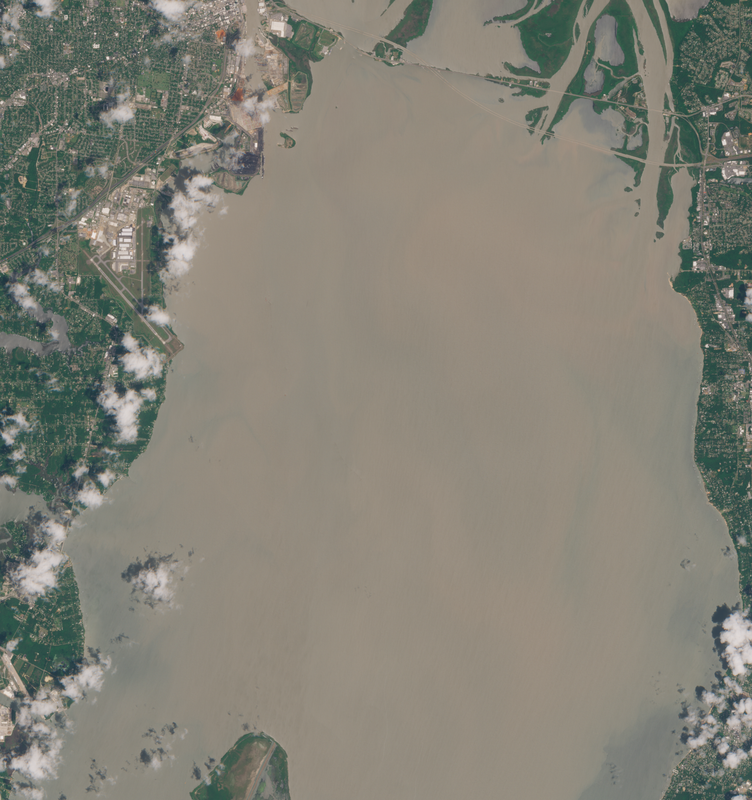
Speaking of observations, here is a visible satellite image from May 23rd showing the mud plume coming out of the north end of the bay ...
-
-
05-29-2025, 11:44 PM #3We are there! Let's go fishing!!
- Join Date
- Oct 2011
- Location
- Born, bred and someday dead in Midtown Mobile, AL
- Posts
- 10,235
- Thanks
- 8,025
- Thanked 13,654 Times in 4,027 Posts
- Blog Entries
- 6
Flood stage on the Mobile River (May 19th) can be verified @ https://water.noaa.gov/?wfo=mob#@=-8...&b=topographic
Last edited by Pier#r; 05-29-2025 at 11:47 PM.
Green_Steel likes this.
-
05-30-2025, 08:04 AM #4Senior Member
- Join Date
- Oct 2011
- Posts
- 198
- Thanks
- 57
- Thanked 282 Times in 87 Posts
Thank ls David. I knew you could bring some data and facts to the topic! Now given that, man's activities nation-wide certainly do contribute to the erosion, so we aren't the hook entirely! As you said, this is just a drop in the bucket.
-
05-30-2025, 05:26 PM #5We are there! Let's go fishing!!
- Join Date
- Oct 2011
- Location
- Born, bred and someday dead in Midtown Mobile, AL
- Posts
- 10,235
- Thanks
- 8,025
- Thanked 13,654 Times in 4,027 Posts
- Blog Entries
- 6
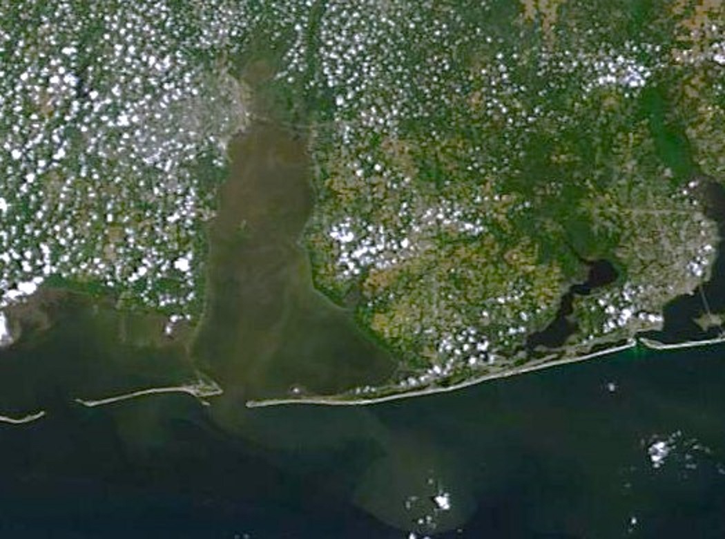
You got me to thinking, there is a free public source of even more detailed satellite imagery that has a searchable database going back several years.
Soar Sentinel 2 imagery is what I have used to chart changes in sandbars along the coast, but it extends inland too.
I searched back from last week all the way to late last year and cannot even find exactly where the mud dumping is taking place.
Agan, I believe it is a bad thing, but to stop it we would need definitive proof of what is happening.
If anyone wants to see for themselves they can follow this link to sign up (it is FREE) and look back through the catalogue...
https://soar.earth/satellites/sentin...a2e68b192a43c4
The following image is from May 16th ...
The image is 415 sq km (about 160 square miles) covering the entire northern Mobile Bay.
Last edited by Pier#r; 05-30-2025 at 05:28 PM.
Dave likes this.
-
The Following User Says Thank You to Pier#r For This Useful Post:
-
05-31-2025, 07:41 PM #6Senior Member
- Join Date
- Oct 2011
- Posts
- 198
- Thanks
- 57
- Thanked 282 Times in 87 Posts
Went out the Lagoon Pass today and the water was gorgeous! You never know unless you go.
-
-
06-01-2025, 06:09 AM #7Senior Member
- Join Date
- Oct 2011
- Posts
- 1,574
- Thanks
- 291
- Thanked 1,577 Times in 404 Posts
Im in the process of trying to build a large barn in Tennessee that the slab is going to poured in four stages. Was supposed to be finished the second week of May. Hopefully well the third pour in tomorrow. Over a foot of rain for the month, broke the 1929 record of 10.2 by 3.8. Had to get a 6 trencher head attachment for my brush cutter in order to keep the garden drained. My 85 year old FIL whos lived on the property his whole life says hes never seen it so wet for so long. All that water has to go somewhere.
-
The Following 6 Users Say Thank You to john g For This Useful Post:
-
06-01-2025, 02:25 PM #8Senior Member
- Join Date
- Jul 2013
- Posts
- 344
- Thanks
- 147
- Thanked 320 Times in 118 Posts
Ive heard theres large Spanish mackerel in that area-did you see any Mr Steel?
Green_Steel likes this.
-
06-01-2025, 04:59 PM #9Senior Member
- Join Date
- Oct 2011
- Posts
- 198
- Thanks
- 57
- Thanked 282 Times in 87 Posts
We fished again today. Caught a nice 10 fish limit of Snapper, then came back to the beach. There are a lot of Spanish and small bonito near the lagoon pass. We caught a few Spanish for lunch prior to coming back in. We also caught some yesterday when we took the grandkids out for a couple hours. They were nice sized, but not "big", most 1-2 lbs. We saw several huge leatherback turtles, a giant manta ray, a large leopard ray, and a couple tarpon in the surf zone (7 ft deep), so a great experience for the kids.
-


 Reply With Quote


Good tip Tom! These two big fellas were screaming like girls when that happened to them last week... LOL
A Spadefish safety tip!